
Nick planned January's Tynecastle Bronze and we waited for the right weather window. Tuesday dull, Wednesday bright sun all day, in St Andrews and Edinburgh. Wednesday it would be. Nick picked me up at 8.30 and we drove to Lower Largo then caught the bus to St. Andrews; the idea being we would run the Fife Coastal Paths back to the car at Lower Largo. Great plan, only one small problem, the weather folk had got the forecast wrong again and the sunshine was limited to the Borders. It was a decent dry day (cold with a breeze) but just not the forecast promised. I took a screen shot of the forecast the day before. It should have been those icons for the sun breaking out from behind a cloud as this was the case for the entire day. Thursday's weather was closer to the mark. I think the salaries of the weather people should vary in line with their accuracy.

wrong

After parking at the car park of Sandy Slither fame we had 10 mins to kill before going to the bus stop so checked out Lower Largo for war memorials. Didn't find any (I think it is up by the main road). The bus ride passed quickly and just before 11 we were running through the university town where we came across this fairly standard war memorial near the cathedral ruins.


St Andrews

I didn't take many photos of the first part of the run. It wasn't very spectacular and the light was flat. Also there were several bits of difficult trail; uneven or stoney gound, stiles and twisty paths. And Nick was setting a brisk pace. I was carrying the larger camera on tripod since we had been promised sunshine and spectacle, and there wasn't much worth stopping for until we got to this unusual sandstone block, the Buddo Rock, the eroded remains of a sandstone shelf.


Nick is smirking here because he saw me get the camera out and hold back. He thought I was anticipating him taking a slip and fall and hoping to capture the moment. Au contraire, (the floor was dry, and Nick was wearing new Hokas) I was just taking a photo of a bridge - and one that could do with a scour and lick of paint. There was a nice bit just after (I failed to capture) as the stream went out to the sea, but I was surprised at the lack of more spectacle. A couple of runners had said they really liked that part of the FCP and I was anticipating more beauty. There were moments, but they were few and far between with long stretches of nothing-worth-a-photo. (Sorry Mike I know you are a big fan.) Maybe I was just a bit cranky because the sun wasn't shining and it was cold. I had anticipated the cold and wore 2 long sleeves and a t-shirt. Given the pace I probably should have worn less. I could feel my clothes get damp and swapped my winter gloves for thin ones which worked better. Nick went without gloves or headcover but pulled the sleeves of his top layer over his hands to keep them warm.


Another complaint! (You would think I hadn't enjoyed this run - I did.) There were several bits where you were obliged to clamber and stumble on rocky foreshore. Some had inland alternatives, some didn't. Most of the route was well marked. I checked out maps beforehand but it was 99% stick to the coastline so didn't even bother printing and carrying one.

Jim H reported feeling unwell on a previous run here and taking a dump in a bunker. (There are several links next to the sea, not always welcoming runners. Wonder why?) I was pretty sure this (above) was the clunker-bunker as it was closest to the FCP (I am assuming Jim didn't cross several fairways to demonstrate his love of the game.) Just in case it hadn't been raked out we didn't inspect any closer.

Constantine's Cave. The local stone appears to be good for eroding in impressive ways often leaving nooks and undercuts. Most of them have some folk lore and a sign nearby with a dubious myth written out for the tourists. I took a photo of the one near this "cave" but it's quite long and I haven't yet worked up the courage to get through it. King Constantine (who?) was maybe killed here blah blah blah. (Several have a Christian flavour which, like a lot of Pot Noodles, isn't my favourite flavour.)

The errant sun spent most of the day doing what Nick described as Bible cover art.

The FCP passes through several charming and picturesque fishing villages. Crail is first up once you turn the corner. I was feeling the pace and suggested we do a quick shop stop so that I could get an energy drink. I was also getting through the fluids I was carrying more than I would usually on a cold day, sweating quite a bit. Both of us had nearly continually wet noses as the cold air condenses in a warm nose. The caffeine drink worked but unfortunately I gave Nick some and he felt a lift as well, picking the pace up again.


more Bible frontispiece

more eroded sandstone
A climbing guide describes the stone as soft which I think doesn't make for good climbing.

Next charming village is Cellardyke. I shared a house with Wendy (and Isabel) back around the late 80s or 90s. (Think: (drunk) Man about the House.) Other than facebook we haven't been in touch much since then but I knew she runs the Haven, an attractive looking pub and restaurant in Cellardyke. I messaged Wendy but she wasn't going to be around when we passed by. Which was shame, but also maybe just as well as we were pushing it to make it back to LL in daylight.

attractive if slightly twee sculpture

The above memorial is for merchant seamen and women who lost their lives in WW2 particularly on the SS Avondale Park the last ship sunk in the Atlantic by U-Boats directly before peace in Europe. This is in Anstruther which follows on from Cellardyke. Article here.

Nick spotted this gate up a narrow alley in Pittenweem and we had a closer look. St Fillans Cave, a much deeper recess, locked, so we couldn't investigate further. Video of interior here.

Pittenweem
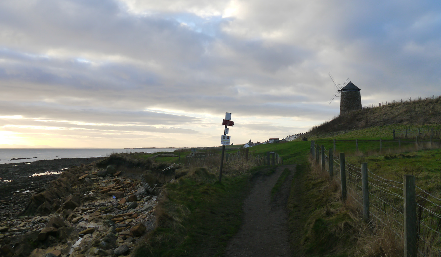
A couple of miles later and the windmill marks the approach to St Monans. All these places have very similar cottages and narrow streets either side of a small harbour. Nick's granny used to live in St Monans so he was familiar with the place.


Newark Castle
I was feeling tired but knew we'd soon be at Elie and onto the (reverse) Sandy Slither, and from there it was only 6 miles. The energy drink and bottle of water I'd poured into my reservoir seemed to be lasting forever, however so did the grassy paths occasionally peppered with stony boulders. Eventually we could see the aerial atop the hill beyond Elie that you run past in the Sandy Slither. Only a couple of miles beyond that.

The silhouette of Arthur's Seat below the Pentlands

The path turned right cutting across the peninsula, taking us into Elie.

Another more exotic wm.
This time Polish Paratroops, to Elie, as a token of friendship and gratitude 1940~1943

We missed the final beach of the Sandy Slither race, instead following the FCP going down the back road in Elie. Which took us out and through the dunes before climbing the hill to that aerial. From there we could see Lower Largo just across the bay beyond the caravan park. This was definitely a boost however I had forgotten the length of the beach. What a long drawn out slog that last couple of miles was. Halfway across and the sun finally dipped below the horizon at 3.48. Around 4pm we were back at the car, and not a moment too soon! I changed out of every last thing I was wearing into dry clothes, as it was all soaked through, and sipped the last of the everlasting reservoir. The heated seats in Nick's car were very welcome and we chatted all the way back to Edinburgh. That's number 30 done - 900+ miles of Tynecastle Bronze. Another good run and thanks to Nick for planning, driving and being great company.


my Suunto said 31.5miles
Nick's Garmin recorded something like a mile further
and we ran about a mile in L Largo before catching bus.

No comments:
Post a Comment