Sunday 29 October 2017

duty vs fun


I have no problem going for a 30mile run on a sunny day but struggle to find the wherewithal to go for a 5 mile training run locally when the weather is a bit crappy. Weekly mileage has been as low as single figures. So I wasn't really looking forward to the cross country relays at Cumbernauld. Haven't done many short fast intervals recently and it showed. And it was 2.5 miles, eyeballs out sprint over grass and mud. I tried to wriggle out of it but as we had quite a decent team of M50s there was an obligation to run the place I'd asked for a few weeks ago. At least the weather was dull and I wasn't missing a great day in the hills or down the coast.

And that's very much where my running is these days. I'm prepared to put in the effort if I can get excited, but have been looking out the window at the rain and dark evenings and opting for wine and netflix. BTW an excellent series we have just enjoyed: Mindhunter. Set in the late 70s and 80s it follows the real life efforts of early FBI Behavioural Science Unit who interview imprisoned serial killers and rapists in order to understand how such people think and apply this knowledge to solving ongoing cases. It is not car chases but more about psychology and characters and what-makes-dangerous-nutters-tick. Filmed in beautifully filtered yellows and turquoises which is exactly the way the 70s looked. It starts with a soundtrack from the era but progresses into ambient and reflective soundscape. Handsomely mounted (museums-full of post-vintage cars from the era) and with some great characters. Thoughtful yet gripping. (And no celebs, no car chases, no huge explosions or people with super-powers; how refreshing!) (Only bad thing is the use of very large text when doing place names. Hope they drop that for season 2!)(Otherwise excellent!)


Great to catch up with ex-Porty Gerry - the old team back together! In fact the thing I enjoyed most wasn't actually the running but meeting old friends and chatting away. And some new friends afterwards too.

here they come!


And what was it like? 15 and a half minutes of hell was what it was like! A whole day travelling and hanging around, for 15.30 running. And I think they may have screwed up the results. Or not published them fully yet. Good to see so many Porties there though. Duty done. Glass of wine (or 2) to recover. 


So the sun obligingly came out for Sunday and the usual down at Gullane. We had a coffee before leaving and then a coffee and jam scone from the Village Coffee House (still overpriced, but nice enough). Mary was now high as a kite having had 3 coffees and was singing sentences instead of speaking them. It was bracingly cold but fine if you kept moving. First day of the season wearing hat and thin gloves to run, apart from the warm up yesterday.


3 egrets (threegrets) at Aberlady bridge.


geese


Above, the butterfly bush as decimated by the ranger and his gang. Now he eventually emailed back to say he was removing (some of) the sea buckthorn, "as part of a long-term plan to re-establish dune grassland habitat on the site". They are also "grazing the area you mention with sheep to increase biodiversity, including the abundance of flowers and so nectar sources for butterflies and other insects. So rather than to their detriment, this work is intended to improve things for our betterflies." Well that's something I'll be keeping an eye on and reporting back on, this time next year. Although they intended to leave the thistles and nettles (the food sources and favoured egg and pupae sites of many species) many of them got a bit trampled while work was going on. It would seem this area, which is fenced off with an electric fence, is probably specifically tested with such experiments and that the butterfly bush was one of the largest groups of sea buckthorn bushes in that smallish fenced off area. There are many areas of greater density of sea buckthorn (like around Marl Loch for instance) but sadly this is the area they seem to fence off, and carry out their tests. Hence the destruction of much of the butterfly bush. Bad luck butterflies. The ranger, John Harrison, also reported that after monitoring them, this year "has actually been very poor for butterflies."

A point of note: since they are now grazing sheep (there were 2 on site today) the current in the fence has been switched on. A medium/light tickle through the gloves. 


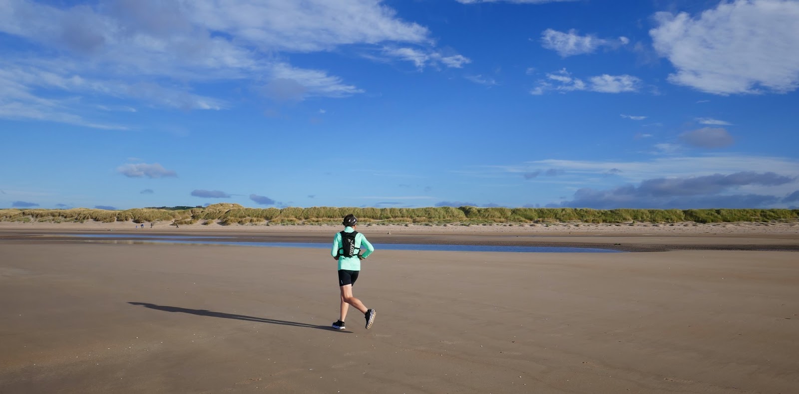
The tide was way out - both subs well clear of the waves. The sun was casting a shimmering light over the sand and the place was empty and vast. For the first time in quite a while Mary suggested we visit the subs and make the most of the good conditions, and smooth sand - even though she had racked up 14 miles yesterday. The silvery expanse of the beach lent itself to photos, as did the sanderlings on the waterline running at a phenomenal speed like they were on wheels. White snowballs zipping along the shoreline checking out stones and looking for things to eat.


3 coffees and Mary levitates


Thursday 26 October 2017

Tweed Valley Ultra Recce and Oct TB


I had planned to do October's TB run on Monday but the forecast sunshine didn't arrive till Wednesday (and I was a little hungover on Monday.) The end of the TB month was fast approaching. I haven't signed up for the Tweed Valley Ultra in November but it looked quite appealing, especially the bit about not requiring Navigation. I was swithering about maybe doing a more local run and wimping out of what looked to be a committing route. But when Wednesday's forecast was bright sun all day (strangely no mention of clouds; visible all day,) I opted for the more interesting route. The deciding factor was a .gpx download of the route on the webpage which allowed me to upload the route to my wrist and follow it like a sat-nav. What could go wrong? (Well I could fall on the hills, hit my head and spend the night unconscious and dying of exposure, but let's not go there.)

Gala XC (Borders Series) course

The business of ultras is all about preparation and not taking risks. Paradoxically it was the prep that nearly caught me out and the daft risks paid off fine. I like to trim my toenails before a long run; better to do this a couple of days prior. So on Tuesday night I put my feet on the end of the bed and tackled the horny gnarled claws with blowtorch and snips. An hour later and a sharp pain was jabbing in the sole of my right foot. I think I must have bruised something on the bottom of my foot while leaning on the bed-end. No time to wait for the injury to ease, and it still felt tender the next morning. No way am I missing a month after 38 months straight and the end of the war in sight. (Packed the paracetamols.) The daft risk was wearing a new top and new shoes I had bought the previous afternoon and not so much run 100yards in. How stupid to go for a 30 mile run in new shoes?

Running up Leith Walk to the train station fears abated as I felt the new super cushiony Speedgoats protect the tender foot. It wasn't a running injury and I could feel it probably wasn't going to deteriorate. Well not for 20 miles or so. Ach it'll be fine, let's do this!


Hoka Speedgoat 2s
A completely different shoe from the Speedgoat 1.

I sat on the train - the first non-peak rate leaving for Galashiels, 09.23 - studying the maps I'd printed out the night before. I'd studied the very detailed gpx file and noted turn-offs and junctions and marked them up on the small A4 printout. I even carried my reading glasses. Only to be told the 9.23 was cancelled and could we get off and catch the 9.56. Bummer. It was nearly 11.00 as I ran across Gala looking for the Academy grounds and the Southern Upland Way marker posts that would cross the Gala xc course and head across a hill or 2 to Yair. This stretch isn't actually on the Tweed Ultra and is just an addition necessary because I thought the train to Gala would be quicker than the bus to Peebles/Innerleithen. It meant joining the Tweed Ultra route at the far East limit and running the second half of the 65k route followed by the first half and then back to Gala. And I'd miss the start and finish at Glentress. But it would be a good indicator of the central 20miles and let me know if it seemed like an interesting course. 


So I didn't have sat-nav guidance for the first 5 miles out of Gala but I did have the Southern Upland Way marker posts. And they followed a surprisingly familiar route of the Gala XC. But then out the woods I couldn't see the next marker. I asked a local dogwalker who pointed at the woods up a hill over there and said yes, that way. There were 3 paths across the field and I chose the middle one as it would be the least wrong. (Should have been left along the wall btw.) And although I was going in the right direction I had to wade across a stream getting shoes and socks soaked through and only 2.2 miles covered. I took a photo of them before they got covered in mud, because I knew that would be coming soon too. I aimed for a cairn on a summit suspecting the SUW headed past it. It did. I saw a Red Admiral (didn't land) which I would have regarded as a good omen if I wasn't squelching along in unnecessarily soaking socks.


But the sun was out, I had a pack full of sandwiches and juice, and nothing better to do than run 30miles. What could be better? The route was reasonably well marked down to Yair but I made a note of how it looked behind me so that when I returned at the other end of the day (perhaps in the dark?) I wouldn't get lost.


I passed about 40 scrawny pheasants sunbathing in the dust at this corner. They were running about like farmyard chickens and I was distracted. I was 80 yards down the hill before I remembered to check for directions at the junction so legged it back up only to find, yes, it is back down. Dick! 


Out onto the tarmac and the bridge crossing the Tweed at Yair. This was another of many memories of routes and races this day brought back. Many years ago Scott and Amanda and I went running around here. A short distance along the road I passed the forest path I would be coming off many hours later. I set my Suunto to navigate, as this was the first of me picking up the Tweed Valley Ultra route, and I could now follow the little arrow on my watch as the twists and turns appeared and moved across the screen. It saved my bacon on half a dozen occasions, and it was far more reliable than any amount of huge maps which I didn't have with me. I did carry the rolled up A4 print-out the whole way in my left hand which was decent back up.


There were tarmac sections but a lot was dirt-pack farm roads.

following the arrow
if you take the wrong way the arrow slowly leaves the line


see that white building way in the distance?


The road on the South of the Tweed is much less used than the one on the North - and at times fizzles out entirely. I was getting used to the feel of it and nearly ran past this forestry trail junction which heads up into the woods. I noticed the arrow leave the line and so turned off the road. I presume there will be big signs or a marshal here on race day as it would be easy (and probably advantageous) to stay on the "main" road. It climbs up into the trees and is rather pleasant!


That white building in the distance up close.


And I was just thinking that you don't see many Field Archery warning signs when the route took another surprising turn off left onto an even smaller trail. I would have defo missed this one without the sat-nav. I wasn't really sure this was the right way it, felt so random. And fun!


Now how did that logging vehicle get up here without churning the path to buggery?


oh

new shoes no longer
and I doubt the path will be any less muddy in November, unless it freezes


see this sweep round the right?
Well the route goes left! Another turn I'd have got wrong.

after another surprise turn right I emerged looking over to Walkerburn

something of a u-turn heads down to Glenbenna

my pal Neil lives here

I warned Neil the night before that I'd be running past his house. He let me know he'd be out at work and while we were both sorry about that, I think in retrospect it was just as well, as a cup of tea would have led to chat, and then musical instruments might have come out, and well, I'd have never got the run finished in daylight or anywhere near. I have memories of a run Mary and I did around here many moons ago, (just added link - it was 2010) on bike tracks in this area and I think we may have come off the hills here, before we knew Neil lived here.


tarmac into Walkerburn - 
take the right junction I think although I can't remember

route goes left onto riverside trails

So although the route goes along the riverbank I went across the Tweed and up onto the main road where there is a war memorial for the Tynecastle Bronze. That was why I was up till all hours and only got 5 hrs sleep - checking wms, since I had used the 2 in Gala on previous. I called in at the Post office across the road for a can of Red Bull. And toggled the Suunto to see how far I had gone. 4.85 miles. WRONG. I realised that when I set the Suunto to navigate, after 4.85miles, I inadvertently hit the wrong button and paused it. Not happy. I reckoned I was now at 14 miles and a bit of chat from the wifeys behind the counter in the PO confirmed this. (I knew I would be able to use the .gpx file to ascertain the exact distance later but knew I had to cover more than 30 miles today to achieve a TB so estimated slightly under. 

I knew I covered nearly 5miles in the first hour over tricky ground. I was now 3hrs in so allowing for photo stops reckoned I was about 14 miles. Checking it later I was about 14.5. I was pushing on at a steady pace but difficulty of terrain was proving slow. I returned to the riverside path and ate a sandwich. I had left it too late and my appetite had gone. I had to force down a couple of sandwiches and only by second was I actually enjoying them. Schoolboy error.


midgey nets


The next part was challenging. I had to ignore the sat-nav and head over to Traquair, the line travelling off the watch face, the arrow deserted and alone on the screen, an untethered space-walk! Although the second part of the race route goes near the first half around Innerleithen I had to leave the course route and pick it up again at Traquair (to make a circuit). Delighted to see the line slide back onto the watch face after a mile in the wilderness.


another Red Admiral near Traquair, another good omen?


another wm
one for next time


I had looked closely at the route on the maps, but not so much I was counting contour lines. I knew the route climbed up into the hills at this point but hadn't realised just how relentless the climb was. 2 miles of nothing but UP! 1200 feet or thereabouts and although most of it is a runnable gradient, it is still quite a hike. Just checked my output and I took 35minutes! But you prob wouldn't be stopping for photos at the not-brilliant but nice enough (damned with faint praise) Point of Resolution sculpture. 


seems to be a monument to dead ponies but not a cemetery?


Point of Resolution. Some ovals cut into the heather and a cast tree. 
The seat is nice after all that climbing!


great views for next half dozen miles


Now, this is where we join the Feel the Burns race route (in reverse). That long diagonal traverse, Minchmoor Road down to Yarrow after topping Brown Knowe 523m. Which is the hill on the left in photo above. Nice to approach it from the other direction and suddenly become aware of where I was. The next few miles follow the FtB route over to the Three Brethren. By now the sun was going down and doing spectacular stuff with the clouds.


the route as seen leaving the Three Brethren doing Feel the Burns

The Red Bull was catching up with me and I nearly had to stop on the hill top
 to add a Fourth Brethren.


The route seemed to be the same as the FtB off the top, but then turned left on a route I hadn't been on before; through the trees for a mile and a half, and back to the delightful point at the end of the circuit I had been on, nearly 5 hrs previously. I had keenly anticipated this exit from the forest and back over the Tweed and was pleased to see that if I made the last 5 miles (4.85 you'll remember) in an hour I could catch the 6.03 back to home, dinner and to paraphrase Nick W, sausage in a bath.


Nearly went wrong, nearly ran out of fuel and forced down a couple of squares of Mrs. Tilly Orange Fudge, found a more direct line across Gala and got to the station in plenty time to buy a bottle of water which tasted VERY fine and scrape the mud off my shoes on the platform. What a day! The weather made it special - if there is horizontal sleet in November then this would be one very tough course. And I didn't have to use the headtorch in my back pack. Result.


new shoes well broken in
wet socks from mile 2 and no blisters or rubs
perfect shoes for the route - plenty of cushioning for the stony paths, plenty of grip for the mud and splosh.

start in Gala far right, ran circuit anti-clockwise
Suunto switched off at Yair, route estimated in blue, switched on at Walkerburn
total distance est: 31 miles plus 1 to, and 1 from, Waverley.

Dinner was outstanding!