Most of the way through October and I was getting jittery. To continue the 4 year Tynecastle Bronze project I had to run a 30miler before the 27th, as I have done for the last 26 months. A week into the antibiotics and the recovery from the alleged Lyme Disease was going well but was I recovered enough to run 30 miles? Tuesday looked as if it would be the best weather window. I had already had one false start as the weather people fluffed the forecast for last Thursday. I hoped the extra few days would make it easier, and this time I would be catching the bus whether or not the day turned out sunny.
It was a bit iffy when I got on the 9.25am Stagecoach to West Linton but when I got off about an hour later, the sky was blue and the sun was beaming. I had chosen this route as I felt it would be relatively easy (HA!) with few surprises - particularly in the second half when I may be struggling.
I was familiar with this end of the Pentlands from the Baddinsgill Round, a great race Nick B organises annually. The race route goes in a large circuit round the hills above Baddinsgill Reservoir. I was intending going up the Old Drove Road that bisects the race route (the hills being very hilly and wet) then taking a right turn at the far end (Cauldstane Slap), over East Cairn Hill then following the easiest direct line to Hare Hill, which I hoped would be about half way. From there I'd drop into Balerno and run the Water of Leith cycle-path home. Or die trying.

There were 4 of us got off the bus at West Linton. All dressed for the hills but I was the only runner. The other 3 gents looked like ramblers making the most of a sunny day. I took a moment to get a signal on the Garmin but quickly moved to the front of our pack on the gently rising tarmac road that takes a couple of miles to get to the reservoir. I set off very slowly knowing if I was to survive the day it wouldn't need to be hurried. Ten minute miles up the slight gradient. 6mph? OK that means 5 or 6 hours. Home well before dark.
Migrating geese honked overhead.
The above pic is near the finish of the Baddinsgill race. It was such good weather I was tempted to get up into the hills right away, but I stuck to the plan to follow the Old Drove Road which was more interesting than I anticipated. I hadn't studied the map in great detail and there were a couple of sections I would plan on the hoof once I got there. The Old Drove Road was a continual climb on dirt trails becoming challenging singletrack, and not the easy dull path along the bottom of a valley I suspected.
The path started well but just before the turn, deteriorated into a stony soggy rutted line through the heather. This was the last time my feet were dry and only about 6 miles into the day - another 24 in soaking muddy shoes to look forward to!
This is the point in the Baddinsgill race where a marshal stands and offers jelly babies and water, so it has good vibes for me. Unfortunately the next section - the climb beside the fence running up East Cairn Hill was soaking beyond redemption and I was immediately immersed shin deep in splosh and swamp. On the upside I came upon this marvelous frog who looked me squarely in the eye as I took his photo.
Above E Cairn Hill a bird of prey soared on the updraft. I hoped it might be a harrier but after looking at the photos on the computer it looks like just a large kestrel. At least it distracted me from the hike up the unpleasantly rocky path - a nasty descent during the race.
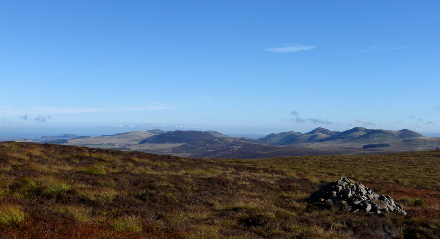
Over the top and you are rewarded with this view of the more familiar end of the Pentlands. I could even see Arthur's Seat and became concerned that there was not 20+ miles of running between there and here. I had only done about 7.
Looking back to where I'd come from - you can see the road above the reservoir.
Just about to make the biggest route error of the day!
The other obligation of the Tynecastle Bronze is to run past a War Memorial. The remit is very wide for this; it doesn't have to be WW1. I had seen Joel post photos of the memorial on Hare Hill to the 4 German aircrew who lost their lives when they were shot down in their Ju88 on their way to bomb Leith Docks and crashed into Hare Hill. Why have I never been there? It seemed like an ideal wm with little in the way of diversion from my route. I would have lunch with the Germans.


I recognised this gate and realised where I was when I saw the logged trail. This was where Nick had danced and skidded in bald Hokas last Winter(?) coming from Carlops via N Esk reservoir. Kind thoughtful people have put logs over the soggy ground and in Winter they are like greasy ice for grip. I was fairly sure they lead to a nice broad trail that drops down to Wester Bavelaw. If I followed it I'd have to turn up the Drove Road to Hare Hill and then descend by the same path. Surely I could find a direct route to Hare Hill that would make a better line. Bad idea. Very bad.


Above: I came down off the hill in the background past the trees. I was very pleased with myself to see this sign and the thin trail that ran alongside the wall in the direction of Hare Hill. The next 2 miles were the slowest of the day. Constantly reduced to a walk it was a real struggle to fight through the heather over lumpy ground. The only person more stupid than myself was whoever left bicycle tracks there. That must have been one hellish cycle and most of it off the bike and pushing. There was a pretty pond on the left of the path, and as I was shaping up the angles for a photo I didn't notice the slot on my right into which I stepped...

I used the pond to wash my shoes. The wall and path didn't go in a straight line - and when it headed out on a long diversion, I opted for a direct line, leaving the path and stomping over the heather. I looked at my watch and said I'll give myself 6 minutes of this and if it is bad I'll turn back to rejoin the path. I turned back in less than 60 seconds. It was criminal, the heather hiding 101 lumps, bumps and pitfalls. I cursed myself. I could have easily trotted along the big superhighway to Wester Bavelaw farm and been sitting with the Jerries having a sandwich and laughing about the old days, and how they might have killed my grandad - an electrician often working in the docks during the war, had they not been brought down, instead of struggling through this rooty tussocky nightmare. Every time I got over the brow of a slight hill and saw the wall disappearing off into the distance, I let out a long string of bad words. There wasn't even any wildlife to distract, except for loads of insects and crane flies.


bad choice
this was the only amusing thing all along that path
(see video at bottom of page)
Finally, after 2 of the longest miles of my life, I came out at that gate where the Drove Road meets the bottom of Hare Hill and enjoyed jogging up to the summit. It was like being met by an old friend after an hour of misery.
where?
Finding the Germans was the next thing. I knew it wouldn't be easy - one blogger said they only found the plane debris and marker post on their 4th attempt. Joel had given me map co-ordinates but I didn't have a scooby about how to put them into the Garmin or about asking the Garmin to show me co-ordinates. Instead I noted that I wanted to be about 300 yards North West of Hare Hill summit and that it was roughly in line with a wall that pointed up the hill from over by the Drove Road. The line to take off the summit is pretty much towards the big white house in the trees (Bavelaw Castle) until you line up with the wall on your left. I thought I'd found it 4 times but it was just markers for the trays of grouse feed the farmers leave out. Eventually I saw a broader marker post over to my right...


I had seen on the internet 4 small wooden crosses with poppies and a wreath beside the marker. The harsh weather had reduced them to resembling much of the remaining rubble from the plane: bits of metal in concrete and perhaps some old leather. It was good to be able to read the names of the flight crew under the reg code of the plane 3E+HM. It was a little too chilly to spend my lunchhour there as planned and instead after bidding goodbye I ate my sandwich and various high cal junk on the descent to the Drove Road.
Look! Actually had the compass out!
Memorial approx in line with this wall.
Down the Drove Road to the gate above Beech Avenue and one last treat. As I was approaching the gate a Red Admiral flew out of the woods on the right. I was gobsmacked and even more delighted when it landed on the leaf litter to sunbathe, letting me get close enough to take a few photos and shoot some video.
I was still concerned about my route being a bit short - I had barely run a dozen miles and had to find another 18. I know from experience there is about 13 or 14 down the WoL paths which leaves another 4 to find. And to add to the complications, I had taken such a long time to cover the first 10 miles the Garmin started to flash up the "Battery Low Warning" at just 8.5miles in. I knew it would give me a couple more hours but I also knew I couldn't count on it sticking around for all 30miles. I had to get a couple of plan Bs, and fast.
But not before a quick circuit of Red Moss Boardwalk. It is one of the best half miles ever and always a joy to bounce along the springy boards. Surprisingly little to photograph though, but having found a frog and butterfly earlier you can only expect so much.
I ran down into Balerno. I had planned on refuelling at the Co-op but since I had plenty in the way of snacks and drink I ran past it, keen to put some sharpish miles in the bank and get home before dark. That was now looking less likely as I was tiring and had spent a ridiculous time doing the first dozen miles. I formed plan B in my mind as I ran onto the cyclepath at Balerno.

I knew certain points on the path and their relative distance to home. I have run the WoL so many times in marathon training I know it far too well. There is a bridge near Doug Runner's house we used to call the Alan Alan bridge as some twat (my guess would be Alan) had graffitied his name on it, twice. It is exactly 10 miles from home and the turn-around point for manys a grim 20 miler. As I passed below I put the Garmin off. It read 15.3 miles. (Hard to believe I was only just over halfway.) My initial plan had been to put the Garmin back on (with remaining but diminished charge) as I passed my house (maybe even drop off my pack - not a euphemism) and, knowing I was now at 25.3miles take the distance up to 30.1 miles by running laps of Leith links or some other local paradise.

The run down the WoL was just about bearable if boring and painful. I remembered I had some paracetamol and gubbed a couple at the WoL Centre. I took a swig from my backpack reservoir and it was virtually empty leaving me to struggle to swallow the dissolving tablets with only a Nakd Bar to help push them down my throat. Highly not recommended. I had only taken about 750mls of fluids knowing the WoL was near shops if required. I so wished I'd taken an extra cupful.
Water of Leith Centre (did not go in)
There were diversions away from the riverside paths from Saughton to Roseburn. On the upside that took me past a Sainsbury's petrol station (round the other side of Murrayfield) selling high caffeine drink and water which I tipped into my reservoir. That, and the paracetamols saw me through the rest of the run. The pace was embarrassing and I was glad I had the Garmin off so there was no record of just how slowly I was rolling along. However I was still rolling. When I got near home I tweaked plan B to avoid running past my front door just in case I gravitated in and couldn't make it back out. I did the General George circuit in reverse - down to the Shore on the WoL, then along Salamander St. turning right at the Links then home, home, home. (I knew it to be over 4 miles which added to the 25+ made 29 and change. Plus the first mile of the day up to the bus station = 30+). Job done!
the first 15 miles from West Linton to Alan Alan bridge
From the Alan Alan bridge there was little doubt that, RTAs aside, I would go the distance. The only remaining question was would I have sufficient energy left to cross the road to the Scotmid and get a beer. Turns out I did, (and home by 5.30pm) though I only managed half a bottle, and maybe one glass of red before flopping, very relieved, into bed.