Back in November 2015 I ran a solo TB utilising the Borders new train service to Galashiels; running back over hills and roads to Gorebridge. I had wimped out at the B709 after 14miles of (tarmac and) moorland, opting for 13miles of road back to Gorebridge station. And have always felt there was some unfinished business running the rest of the way to Gladhouse Reservoir. The ground as far as the B709 was sploshy but ok (in November) and I felt the dry April (driest Edinburgh April in 75 years) would make decent going to that point and then beyond on the hills above Glentress. Nick had a few days off and this lined up with Wednesday's extremely sunny forecast. What could go wrong???

Last time I used Gala's excellent town centre wm (below) so this time I did some googling homework and found that the church near the station (Our Lady and St Andrew) had a couple of war memorials. Trouble was they were likely inside. It was with slight trepidation I tried the door - open! - and went in. (Our) lady luck timed our visit to coincide with a cleaner and I explained we were interested in the War Memorials which she pointed out, either side of the aisle, one for 14~18 (above) and another for WW2. As that sweary chef says, "job done!".

Last time I ran the main road to Clovenfords. This time after more googling homework (though not marked on google maps) I had seen a small path running parallel to the A72 near Gala Water. 100 yards on the main road then off again on the Torwoodlee path taking a much prettier route through the fields to the other side of Clovenfords. So the first 6 miles were rather lovely and full of chat. There was then a quite steep climb for 1.5 miles on a road that deteriorated (or improved if you are a fan of dirt trails) as it crossed several cattle grids topping out at 1200'.


topping out at 1200'
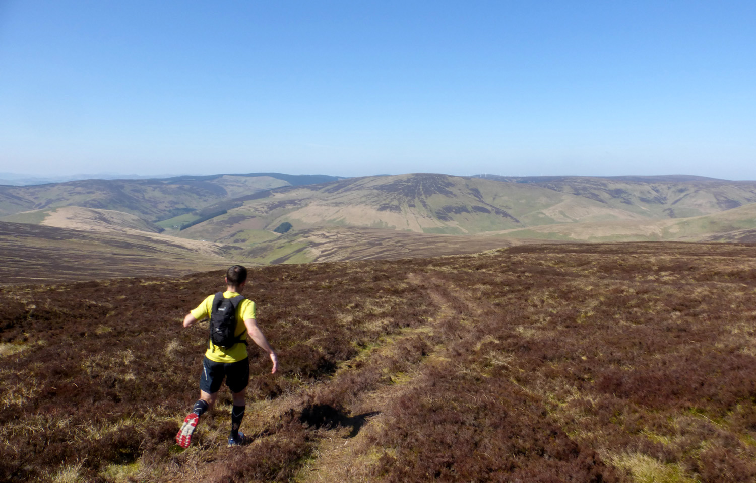
We were now onto dirt trails proper and there was no further traffic apart from farmers in 4x4s looking out for lambing sheep. The good fortune and splendid weather made me relax and, of course, I took my eye off the ball. Last time I had come this way I was diligently checking the map, looking out for the sharp left turn to travel up towards Redscar Law. It had been about the ten mile mark. So around 11 miles we realised we had missed it. Sure enough it was a mile back and so obvious it was difficult to believe we had run past, no doubt blethering like fishwives. What is a fishwife? Well they're not as stupid as dudes who run an extra 2 miles because they are not paying attention. I was nearly annoyed but the weather was just outstanding and it was all going so well. It continued to go well although the track deteriorates from here on as it climbs up past Redscar Law 563m to Windlestraw Law 659m. This is quite a hike with substantial up hills.

ran past this junction - what twats


a miniature Nick slackwires on the fence

bench mark at Windlestraw Law
I had recently re-calibrated my suunto altitude and was pleased it was only 10m out.

while it was a pleasure to run downhill I noticed progress wasn't all that fast
maybe 8~9min miling due to lumpy ground.

From here the route descends (past Wallet Knowe) (where is my wallet now?) to the B709 which is where I wimped out last time. It was November and 2pm. Although I had a headtorch and handtorch there were unknown miles of hills ahead and it seemed a better prospect to take the road back North. This time we would slog up the thousand foot climb (photo below) and travel where few humans had ever been in a roughly straight line to Gladhouse Reservoir. My main concern was water. I had consumed 2/3rds of my litre and a half reservoir and we were only halfway. I knew there were some houses down at the road and wondered if we could blag a refill from an outside tap. We had had a good deal of luck today so far and that continued when we met a farmer lady who was busy with the lambing. She allowed us into the large byre to fill up our reservoirs while her puppy Ross snuck around our salt lick legs and the orphaned lambs baa-ed in the background. She pointed us in the right direction across the field on the other side of the road and we set off up the huge climb at 12.37, trying to avoid the brown patches at the top of the hill which were shin deep heather and slowed progress. I was delighted to get a water refill as it was a very warm journey and we would have otherwise been forced to drink from rare streams and puddles. I was still feeling lucky at the top of the climb.

thousand foot climb took nearly 30 minutes
note farm buildings bottom right which saved our freshwater lives

I had been reviewing the untested route over the hill tops. It looked like it might be better to stick to the high plateau rather than my initial mapped route of heading through the woods, losing and then gaining height. I had spent some time zooming in to google earth maps to see shadows of quadbike trails and what might be paths. It was inconclusive and when we got there it seemed like staying on the large round might be the thing. It started on a path but quickly we were crossing swathes of unmarked heather and tussocky ground. This was heavy going and quickly we were forced to walk. We were surprised to see a couple of walkers and should have gone over to them for a chat. It was long way from anywhere and if we had known what the next 4 miles held we would have really appreciated the chance to swap route advice. They seemed to have come from the direction we were heading. However we weren't inclined to travel an extra 200 yards and so headed forward; right of the wooded area, similar to the dotted line on the map above.
It was a mile of uphill from the road (the 18th of the day) and that, and the next 4 were possibly among the worst 5 miles of my life. Imagine the worst part of the Ochils 2000 - the blind struggle over peat hags. And the bad sploshy bits of the Baddinsgill Round. Well that. But continually for 2 dreadful hours The climb was a 30minute mile, followed by a 22min mile, then a 21, then a 28, then a 20. I didn't take many photos, and I should have, just to show the unearthly landscape of continually undulating peat hags and heathery hell that we stumbled across, trying not to twist ankles or step knee deep into the green slime ponds that littered the martian fuckscape. We would see marker poles marking trays of grouse pellets and think they must be indicators of better ground. And we would stumble and trip over to them only to find they were in no way advantageous. We would pick up a quad bike trail for a hundred blessed steps then it would disappear and we would have to climb down and up the 12' sides of a spongy peat crater. It was deeply unpleasant and I had to apologise to Nick for dragging him through this awful battleground. The names on the map - Garvald Punks and Rough Moss - only go so far in describing the hellish infinite torture.

from the top of the climb

we hoped this was a path
it wasn't

I thought I had seen tracks near the woods on google maps
couldn't find any


miles and miles of hard going and heathery peat hags

dear, blessed Arthur's Seat
Despite the outlandish ground we kept on course by aiming for the highest shitmound, Blackhope Scar 651m. I think there may have been a trig point there. I had been trying to eat a sandwich. Bite, chew, chew, chew, chew and chew some more then 5 mins later swallow. A couple of mouthfuls I spat out as they were getting nowhere. It took a lifetime to eat one slice of bread and honey. I felt weak with lack of food but nothing appealed. The normally extremely welcome Double Deckers sat in my pack untouched, unloved. I knew I had to eat - we still had a long way to go. But everything seemed too dry and inedible. I was extremely grateful for 2 things: the water we had got at the road which I was getting through mighty quickly and the fact that last time I did this route I took the road. The thought of those 5 miles in the darkening cold of Winter was unthinkable. I could easily have died, or worse.

As we crested Blackhope Scar the view opened out to the Pentlands and down to Arthur Seat and the coast. This and the terrain improving gave us a boost. Soon we were cruising downhill faster than 10 min/miling heading towards A REAL TRAIL beyond New Moss and The Kipps. The trail appeared exactly on cue and I was pleased that although the terrain had been extremely challenging we had never lost our way crossing it. "Everything else should be a dawdle by comparison".


back on proper trails - what a relief


Now we were back in the land of the living I called time out for a shoe empty. I could feel some heather bruck in my left shoe that I couldn't shimmy into a comfort zone. When I took it off there was a dyson worth of compressed organic material. I only realised it would make a good photo after I had brushed it off, and the right foot extracurricular material (above) is less impressive. My, how one's feet feel better after a clear out though. On the downside this was mile 24 and we still had about 9 weary road miles left to pound.


I apologise for not taking the time to shoot some cute lamb photos. There were a few opportunities but I had devolved to survival mode and it didn't seem important.


slowly, very slowly we kept knocking out the miles


great, a hill


The last hour is a heat stroked blur. It was very pleasant running. Or would have been if it were not for the preceding, and the lack of sustenance. A lot of my foodstuffs remained uneaten and I was definitely suffering as a result. Nick seemed in better shape than myself and when we stopped to check a junction I'd just hand him the map. We opted for direct rather than scenic, heading to Gorebridge Station after going past Gladhouse Reservoir which looked very pretty and swim-wise extremely inviting. The end couldn't come quick enough. However it was quite a plod. We did manage sub 10min miles for the last 8 or 9. But I looked longingly at the transit van we passed near Temple, trying to will the driver to offer us a lift. No dice.

For a LONG time I was fantasising about the first shop we would visit getting into Gorebridge. Nick let out a cheer when we turned a bend and there it was, a corner shop with a freezer full of cold drinks. We both bought a couple (reservoirs being long emptied) and stood in the baking sun making appreciative noises before walking zombie-like to the station, 4.26pm, a minute ahead of the next train. HURRAY! Which was cancelled. BOO! To cut a long story short including a phone call to PRC's Pat K from one of his mechanics (did I dream that???) we had to walk back out to the A7 and wait the remainder of another hour on the Borders bus which our overpriced rail ticket (the result of getting to the station at 8.15am) at least paid for. The jog down the Walk from where we struggled off the bus started slowly but improved. The official distance figure was 33.35miles from Gala to Gorebridge then prob half a mile back to the bus stop, plus one up to Waverley and nearly one back down from town. Between 35 and 36 miles for the day. I was too tired to make it back out to the shops for beer, it was THAT bad! But really very good as well.
No comments:
Post a Comment