
The forecast was sunny although windy so Lucy and I made last minute plans on Friday evening to do another long run across East Lothian. I asked her if she fancied the Southern Upland Way or the Herring Road and she opted for the latter, being keen on adventure and preferring the road less travelled. We had seen signs for the Herring Road last week and it offered a more direct route to Dunbar from Lauder than the S.U.W. However being a point to point it also required a bit of travel planning. She would drive to Dunbar, leave the car at the train station, and catch the early train to Waverley, walk to the bus station where we would meet and catch the first Perryman's bus to Lauder at 9am. We arrived at the War Memorial at 10.20am.

This was of course at the wrong end of Lauder, however when the day's mileage is over 30 then an extra half mile (to claim the Tynecastle Bronze) doesn't really matter.

Lucy was much amused by the Single Occupancy Toilets

Thirlestane Castle

The Herring Road shares the S.U.W. for the first 10 miles before taking a more direct line towards Dunbar.
"The Herring Road is thought to have been predominantly in use during the 18th and 19th centuries when the herring industry was strong, although records of the inland trade in fish go back to the mid-17th century. The route was used by people bringing home a stock of salted herring for winter use and also fishwives carrying huge creels of herring from Dunbar to the markets in Lauder."

The path leaving Lauder is pleasant although the weather wasn't particularly. A combination of farmlands, and woodland paths leading to the open foothills of the Lammermuirs.

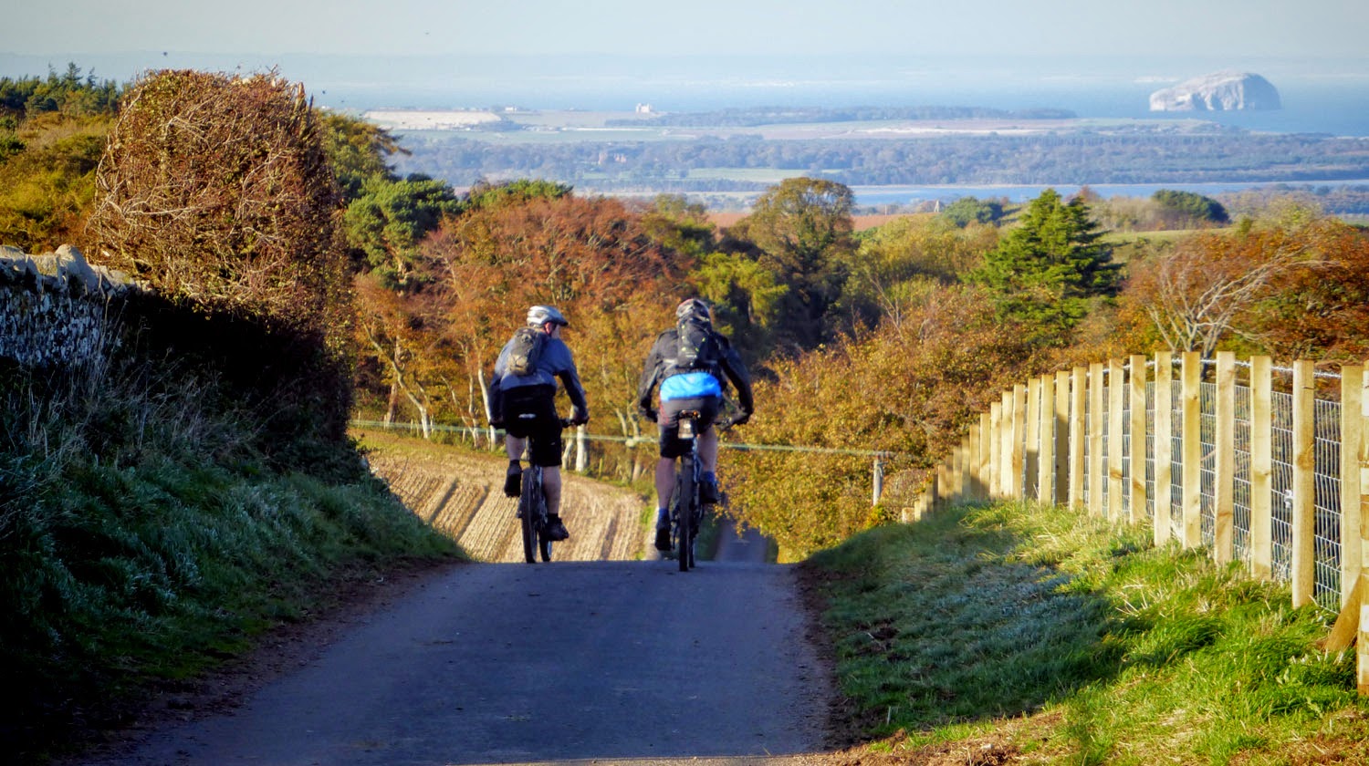
Just out of Lauder we met these 2 pushing their bikes up the hill. I thought they might be doing the S.U.W. but they said they were doing the Herring Road as well. They asked if we hoped to do it all in one day. I replied there was no "hoping" and we certainly would be doing it all in one day. Actually we hadn't planned any escape routes or alternatives or what-ifs, so were kind of obliged to finish the route or die trying.


Due to this field of turnips we were sidelined round the edge which wasn't too bad for us but less convenient for the guys on bikes. We were all moving at around the same pace - the bikes faster on the smooth paths and descents, the runners quicker over rough ground and off-road climbs.
"Nice Turnips"
"Sweet"
"Did you say Swede?"
"Neeps"

that bridge

The sky began to clear.

Heading for the woods. We were covering about 5miles per hour.

The long sustained climb on grassy tracks after the bridge gave us quite a lead over the bikes. They were hoping to keep us in visual contact so they wouldn't have to get their maps out. I watched for them scooting down this track out the woods but there was no sign.


For quite some time you can see the two cairns of Twinlaw Cairns on the horizon.


The skies were blue but the stiff breeze meant it was cold for sitting around.


At the second cairn there is a book in a tin and if you write your Christmas list in there, an email is sent directly to Santa.


Like a couple of dafties we chose this, the most exposed point on the whole route, to have a quick picnic and take selfies. Jackets on for the duration. Garmin off. (Mistake.)

Seems like we weren't the only ones - our biker pals appeared and had a break at the other cairn.

We set off before the bikes. I knew they would have the advantage with the next mile being a lovely downhill to the newly broadened windfarm road. At the bottom Lucy remarked something about time or distance and I cursed - I had forgotten to switch the Garmin back on after lunch. My jacket sleeve hid the evidence until I took it off at the road.

The bikes went past again. We now had to run with the map out and check regularly as everything from this point onwards was new to me. I had bought a new map cover since throwing away the previous one last week. Lucy had done some miles with a pal near Whiteadder Reservoir so was familiar with that section.

There was a bit of a hill before Whiteadder, and again we overhauled the bikes.


When speaking to our new bikey pals I had been forced to mention Whiteadder Reservoir and with a great deal of reluctance and sniggers from Lucy (ref last week) had to pronounce it Whitadder. It was looking very deep and blue and cold in the chilling wind.

We stopped several times for refreshments.

And judging by their progress so did the bikers - seen here as tiny silhouettes on the horizon top left. We had another snack here - Lucy was feeling tired and had a bit of a dodgy tummy. Probably not helped by going from no-miles-a-week to 2 x 30milers in 8 days.

Target practice drum doing a great impression of the Autumn colours.

Back to Crystal Rig windfarm.
This week we were a bit more cautious, however the Herring Road was signposted quite well and cut diagonally across the paths of the turbines. Some of the ground was a bit rough and we caught up with the bikers again.


Posts with red tops marked the way.

Checking out this shed one of the bikers was struck on the head by an owl.


The signposts were very welcome. Anne H (Dunbar) said you used to be able to navigate by the trees more easily here, but they have mostly been cut down. (Unsmiley face.)


After the windfarm, which covers quite a few square miles, there were some good trails across Dunbar Common, slightly rising, contouring round Watch Law, until they gave way to the long awaited view down to the coast. You definitely got the feeling it was in the bag from here.


We were ahead of the bikes at the point we came to a junction marked Scotsway or something. On the map it looked like a direct descent down steep ground (Lothian Edge) and that the official route descended a more gentle slope to the right which swept back round left joining the bottom of the steeper line. Somewhat snatching defeat from the jaws of victory (nobody said this was a race?!) I suggested we take the gentle but longer trail, and the bikes snuck ahead on the shorter direct line. They were always going to have the advantage once we hit the last few miles of descending tarmac into Dunbar, but I thought we might be able to get to that point before them while still on rougher ground. We could see they were a minute or two ahead through the last couple of fields.

It was a nice touch to wait for us at the start of the tarmac. We had a last brief chat (having exchanged pleasantries and places all day) before they zoomed off on their last easy 4 or 5 miles. I reminded them we would be working to cover the ground they would coast over while sitting down.


An occasional breather was called for.

Then back up to pace for the last handful of miles. Pleased to report mile 27 was the quickest of the day at 7.36 min/miling. (Almost as fast as a bike.)

We both agreed it was a tremendous day out - right up there with the best of them. Of course it helped that the sun was out, lighting up the Autumn colours, making the views so much better. However it was quite an improvement on last week as most of the route was off-road (and over wild and woolly countryside) apart from the very last bit. And the satisfaction of following an unknown route over a long day out without getting badly lost, (or losing the map) added to the fun. And "racing" in tandem with the bikes was a great distraction and gave us something to consider other than just how tired the legs were.
I couldn't find huge amounts of info on the Herring Road. It is really quite well marked / signposted, although you would definitely want to carry a map especially if you are not familiar with the S.U.W. The best map I found, and it was the one which I used to mark up the map I printed out and carried is linked below - be warned it is so old it doesn't even have WhitEadder Reservoir on it.*
Heritage map of Herring Road here go to bottom of page (above images) for map.
Route description is from Dunbar to Lauder
*Just realised if you click on the box that says Historic Bartholomew 1912 it has a drop down menu to toggle modern maps. D'oh.
The Garmin measured 29.67miles (moving time 4.55, elapsed time 6.05) from Lauder War Memorial to Dunbar near the station. Looking at the output I reckon we travelled 1.5 miles from Twinlaw Cairns with it off.
Great post Peter, An ace old crossing of our hills.
ReplyDeleteFrancis and i planned to horse ride/cycle the road this Autumn until she bust here collar bone!
Thanks Bruce - it is the best line I've taken over those parts - I preferred it to the SUW and the way through the turbines is well enough marked to make it fairly straight forward, although it is a slight hassle to organise the Lauder / Dunbar travel.
ReplyDeleteHope Francis is on the mend - pass on my best wishes.
Hi Peter,
ReplyDeleteI enjoyed your blog and photos.
We,"your new bikey pals" both had a great day and having some company along the way made it all the better.
As you said "it wasn't a race ;-) " but I have to admit, the thought of you and Lucy beating us back on foot (with those big backpacks) certainly helped keep us motivated.
We will keep an eye out for you both when we are next out on the trails, and who knows..maybey we will give you both a wee head start next time ;-)
cheers,
Keith.
Glad you found your way here Keith. It was fun!
ReplyDeleteHappy cycling!
(I refuse to rise to the "head start" bait and all things considered I think we must have inadvertently given you a head start on the Herring Road, since we caught you up on the climb out of Lauder.) I would be tempted to organise a runner vs biker day out but last time that happened I spent 5hrs gasping while Coastkid ^ chatted, not out of breath at all. Various bits of the Herring Rd I was glad not to be pushing a bike but the last miles from the tarmac was definitely harder going on shanks pony.
http://bestpartday.blogspot.co.uk/2013/10/30-miler-with-coastkid.html